Tuesday, August 23, 2016

WWI Concrete Ships

The SS Palo Alto in late evening light.

Historical Concrete Ships to Serve as Emergency Fleet in WWI

Toward the end of the First World War, the United States commissioned the construction of twelve experimental concrete ships.  None of the ships were finished until after the end of the war.  Most were eventually sunk as breakwaters or recreational piers.  Here is the story of three of them:  the SS Palo Alto and her sister ship the SS Peralto, and their famous East Coast cousin the SS Atlantus.

During a recent afternoon at the Seacliff Beach on a sunny afternoon, I waited until sunset and captured these images of the SS Palo Alto as it serves as a bird sanctuary for cormorants, brown pelicans, gulls, terns and other sea birds at the end of the old pier.  

SS Palo Alto

A unique pier in Aptos isn’t just a pier…it is also home to a historic WWI era concrete ship that once floated offshore as an entertainment vessel for dining, dancing and fun. Known as The SS Palo Alto (“The Cement Boat”), you’ll find the historic ship located south of Santa Cruz off Highway 1, at Seacliff State Beach. This two mile, sandy beach at the foot of sandstone cliffs offers day parking, camping, swimming, fishing, bicycling and roller blading for starters. The pier is easily viewed from land or air as you fly out of destinations such as Monterrey.


The SS Palo Alto was built by the San Francisco Shipbuilding Company in Oakland in 1919 as an oil tanker for the World War I effort. The war ended before she ever saw service and with time on her hands, she was sold to the Seacliff Amusement Company of Nevada, and towed in 1929 to what would later become Seacliff State Beach. A casino and dance hall, arcades and entertainment were featured on this monster party boat until its owners went belly when the Great Depression rocked the world in the early 1930’s.

Today, the Palo Alto sits on the floor of the Monterey Bay. One of the most photographed landmarks of the region, birds have discovered a haven not accessible to humans. Bring a pair of binoculars to watch the hundreds of birds that sit on the ship. Time has taken its toll on the ship and the cement is cracked and crumbling, yet it is still a sight to see. Beach facilities where you can enjoy watching birds include a beautiful stretch of sandy beach, covered picnic areas with barbecues public restrooms, trailer campsites and an interpretive center which has natural and local cultural history exhibits.

SS Palo Alto on the end of the Pier, now broken in at least 3 pieces.


SS Palo Alto at the end of the historical Pier


Warm light at the end of the day


The Pier after Sunset


At the end of the day...


SS Peralta

The SS Peralta is the sister ship of the SS Palo Alto, built as an oil tanker also by the San Francisco Shipbuilding Company and launched in February of 1921.  In 1924, the Peralta was purchased and converted into a sardine cannery in Alaska. 24 years later, the ship was moored off Antioch, CA.

Finally, in 1958, the Peralta was purchased by Pacifica Papers to be used as part of a giant floating breakwater on the Powell River to protect its log storage pond. She floats aside several of concrete ships built during World War II.  The Peralta is still afloat as part of a breakwater for a pulp and paper mill in Powell River in British Columbia, Canada. She is the last ship of the World War I fleet still afloat. At 420 feet, she is also the largest concrete ship afloat.

In December of 2000, the mill was downsized as the result of a corporate merger between Pacifica Papers and NorskeCanada. The mill no longer processes raw materials, so they were planning to remove a few ships from the breakwater. There was discussion of sinking the Peralta as an artificial reef; however, the company changed its mind and decided to keep all ten breakwater ships. The Peralta is safe for now.
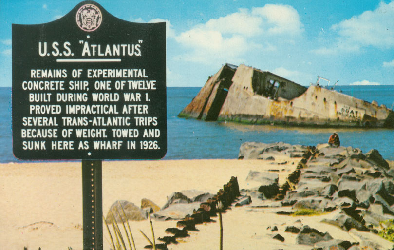
SS Atlantus

The 3rd concrete ship, the SS Atlantus was built by the Liberty Ship Building Company in Brunswick, Georgia and launched on December 5, 1918 and was the second concrete ship constructed in the World War I Emergency Fleet.

The war had ended a month earlier, but the Atlantus was used to transport American troops back home from Europe and also to transport coal in New England. In 1920, the ship was retired to a salvage yard in Virginia.

In 1926, the Atlantus was purchased by Colonel Jesse Rosenfeld to be used as ferry dock in Cape May, New Jersey for a proposed ferry between Cape May and Cape Henlopen, DE. The plan was to dig a channel into to the shore where the Atlantus would be placed. Two other concrete ships would be purchased to form a Y-shape where the ferry would dock.

In March 1926, the groundbreaking ceremonies were held for the construction of the ferry dock. The Atlantus was repaired and towed to Cape May. On June 8th, a storm hit and the ship broke free of her moorings and ran aground 150 feet off the coast of Sunset Beach. Several attempts were made to free the ship, but none were successful.

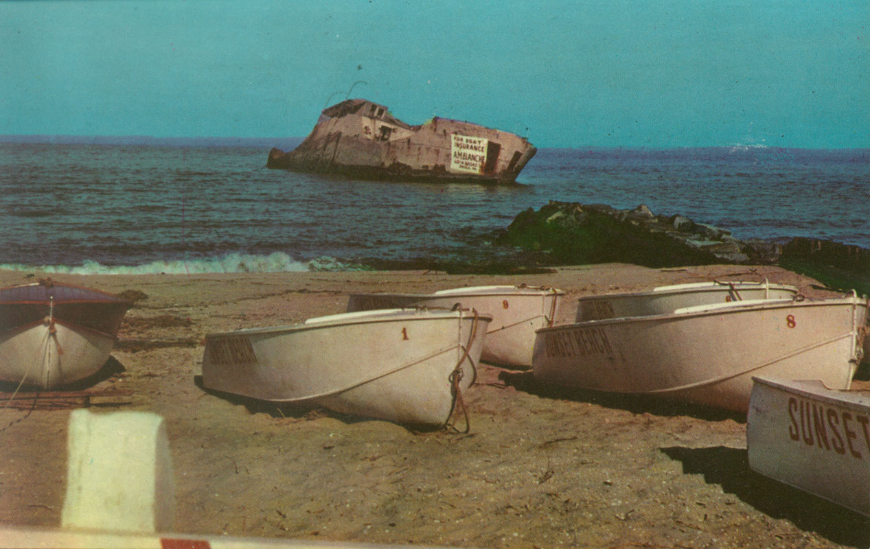
Since then the Atlantus has become a tourist attraction seen by millions. People used to swim out to the ship and dive off, until one young man drowned. At one time, a billboard was also placed on the ship. Starting in the late 50's, the ship began to split apart in the midsection.

The S. S. Atlantus can be seen at Sunset Beach in Cape May, NJ.  As with the SS Palo Alto, unfortunately the ocean has taken its toll on the ship and she has broken apart. It's only a matter of time before the last of her remains crumble beneath the waves.

[Ref: (1) http://concreteships.org/ships/


 I hope you enjoyed this little bit of maritime history.

Til next time,
Meggi

Monday, July 11, 2016

Bears in Sequoia NP


Searching for Black Bears in the Sequoia National Park!


The last week, I had the chance to join Photographer Brent Paull ( www.amwestphoto.com) at the Sequoia National Park in search for black bears.  Brent knows the park very well and has photographed bears in the park many times.  So I had high hopes to see and capture bears, maybe even a sow with cubs.  We set out early in the morning with first light and made the 1-hour track into the park on Generals Highway – including 50 switchbacks and an impressive elevation gain - up to the Crescent Meadow area.  Setting out with camera, long lenses and tripod, we started hiking in this lovely area dotted with green meadows.  Although the California hills are pretty golden with dried grassland at this time of the year, it was astounding to find these meadows full of lush grass and colorful spring flowers, a perfect setting for bears searching for food.  I wondered how these meadows stay green even in the summer’s heat?   

                 Early Morning under the giants (Sequoia Trees)

Scanning the landscape, the granite rocks form ‘bowls’ surrounded by higher ridge, and when the winter’s snow melts the water collects in the ‘bowls’.  Over the years sufficient sediments collected to give enough ground for the meadows to establish.  With no outlets for the water other than evaporation, these areas stay moist all summer long providing great areas for grass, flowers and berry bushes to flourish.  It’s not only the black bears who find juicy grass in the spring, pine cones in the summer and berries in the early fall to satisfy their hunger, but these meadows are also great for seeing marmots, chipmunks and other small critters, deer as well as a rich bird life.  In some of the meadows, small ponds form at the lowest points offering bears who love to swim a place to cool off in the summer’s heat.


Purple flower at the edge of the small pond

Hiking in the higher elevations of the park, these meadows can be reached by hiking over the ridges through the open pine and sequoia forest. 
During my 2 days in the park, we visited 4 different meadows, one prettier than the next.  Starting out early at sunrise, we were the first day hikers and were surrounded by quiet only broken by bird calls and the sound of crunching sticks and needles under our boots.
Reaching the second meadow on the first day, Brent stopped and in a hushed voice pointed to a bear in the meadow.  With the grass quite high and the bear in quite some distance, only its head and ears reaching over the meadow’s green.  We watched for a while how his head dipped up and down in a peaceful rhythm, eventually disappearing into the forest.  I love being out in nature, being able and privileged to witness wildlife away from the hustle and buzzle of daily life.

At the edge of a meadows, the roots of fallen trees make perfect dens and lookouts for marmots.  This young marmot enjoyed the warmth of the early sunshine eyeing us with little interest.


Very well camouflaged, a doe rested in the root base of an enormous sequoia tree.


Around another bend we found a cinnamon black bear deep in the grassy meadow much closer to where we were hiking at the forest edge.


She looked at us and quickly moved on into the deeper meadow ….


Leopard Lillly

Visitor searching for nectar in the little purple flowers


The next day, again setting out at sunrise, another bear crossed our path, looked up and - unfortunately for us - very quickly disappeared into to the forest.


But birds, marmots and flowers offered rich photo opportunities:


Western Tanager in breeding colors (orange head colors)


Adult marmot on the lookout


Marmot warming in the morning sunshine


Tiny but beautiful - flower on the forest floor


Valley and Ridges - structures of the pine tree bark


Afternoon in the Meadows and Forest


The days at the Sequoia National Park proved again how fortunate I am living in California, a state with so much natural beauty from the ocean to the mountains to the desert, such a diverse natural landscape rich in flora and fauna – a photographer’s paradise.

I hope you enjoyed this little glimpse into just one corner of our lovely state.


Til next time,
Meggi


Wednesday, June 22, 2016

State of North American Birds

Great Horned Owl

A new report reveals that of the 1154 native bird species that occur in continental North America, one third require urgent conservation action. This report was published on the 100th anniversary of the Convention for the Protection of Migratory Birds between the US and Canada, and it is the first assessment of its kind showing an alarming state of North American migratory birds.

New report shows alarming state of North-American birds


Since the seventies, millions of North American birds have disappeared and a third of species are now of high regional conservation concern, a new report reveals.

Experts agree that their long-term conservation will only be achieved by building transnational partnerships and involving local communities in citizen science projects.

Migratory birds connect the North American continent as millions of birds move across the US, Canada and Mexico every year. An estimated 350 North American bird species share their distribution across more than 2 countries, underlining the importance of coordinated action to protect them.


The greater sage grouse faces pressure from fragmented habitat resulting from 
development across the West. (Photo by Stephen Ting)

Until now, the vulnerability score of over a thousand native North-American bird species was incomplete. ‘”The State of North America’s Birds’’ fills the gaps. Published on the 100th anniversary of the Convention for the Protection of Migratory Birds between the US and Canada, it is the first assessment of its kind.

The report reveals that of the 1154 native bird species that occur in continental North America, one third require urgent conservation action. The species in need of most urgent action are those that depend on oceans and tropical forests.

Specifically, the most regionally endangered group are seabirds – more than half of them are of high conservation concern and affected by a mix of pollution, overfishing, impacts from energy extraction, predation by invasive species in islands and climate change. The seabirds with the highest concern score are the Black-capped Petrel Pterodroma hasitata, Black Petrel Procellaria parkinsoni and Townsend’s Shearwater Puffinus auricularis.

The situation is not much better for tropical birds. Canada’s migratory songbirds winter in Mexico’s tropical forests and stopover in the US, which is why the impact of deforestation in Mexico has such a huge impact throughout the continent (see Photo 2). Other tropical birds with high concern scores are Azure-rumped Tanager Tangara cabanisi, Bearded Wood-Partridge Dendrortyx barbatus and Belted Flycatcher Xenotriccus callizonus.


Magnolia Warblers rely on an area of tropical forest in Mexico for the winter. 
The map is based on complex computer models, making use of millions of Citizen Science 
records contributed to eBird. Infographic by BSC Andrew Couturier

This unprecedented continent-wide analysis also reveals how grassland birds are facing some of the steepest population regional declines of any group because of changes in land use.

In recent years the vast prairies of North America have mostly been turned into agricultural land or developed. Only a few islands of original land remain, making it very difficult for wildlife to survive.
Some of the grassland species with the highest concern score include Sierra Madre Sparrow Xenospiza baileyi, Worthen’s Sparrow Spizella wortheni and Lesser Prairie-chicken Tympanuchus pallidicinctus.

Bird Studies Canada (BSC) President Steven Price explains some of the outcomes of the study in this interview.
“Our research and conservation work is supported by countless generous bird lovers. This report reflects the contributions of tens of thousands of dedicated volunteer Citizen Scientists” said BSC President Steven Price.

The report was put together by the North American Conservation Initiative and was built using data collected by volunteers and citizen scientists across the continent.

Despite the alarming findings, the report demonstrates how the power of many can help us understand conservation needs and drive positive change. The results are a call to action to public and private sectors to come together to save migratory birds.


Three BirdLife Partners, Bird Studies Canada, Nature Canada and the Audubon Society, were among the North American Bird Conservation Initiative partners who collaborated on the new report. View the report online at www.stateofthebirds.org


 Prairie Falcon

Cactus Wren

Northern Pintail

Til Next Time,
Meggi

Friday, February 5, 2016

Bobcat

Field Observation of a Wild Bobcat

Bobcat with Quail in a Dead Tree

In January, I spent 2 gorgeous days in and around Pinnacles National Park in search of bobcats.  For this exploration, I had signed up with Photographer Brent Paull [amwestphoto.com], who knows the area very well and has had many great encounters with bobcats and other wildlife that he shares on his website. 


I met up with Brent early in the morning of the first day and not only did we have 8 bobcat encounters on the first day and 3 more on the second, Brent did all the driving in his very comfortable truck.  Thank you, Brent!

Our destination was Pinnacles National Park in San Benito County but we also drove wonderful small country roads in the back country where due to the plentiful rain this winter the hills were lush green with the early mustard just about to bloom.  Besides the wildlife, it is a great area to photograph landscape with old barns and gnarly black oak trees – but that was not the focus of our exploration.

In my story today, I want to describe our first encounter with a bobcat that depicted true wildlife field observation of nature in action.  Due to the distance to the bobcat, this was not the greatest photo opportunity but I loved every minute of observing these shy and elusive cats in their natural habitat, doing what they do every day:  scouting their territory and hunting for their next meal.  As I saw later, the bobcat was successfully hunting for a quail.

I am showing the images as they were taken, with the bobcat in a distance – small even with a long tele lens.  The images were taken with a Nikon D750, Nikon 200-500mm lens, using the car as a blind and photographing out of the window.
We spotted a bobcat in a distance in a shrubbery horse pasture as it moved along an unpaved country road.


All of a sudden the cat’s interested became focused:


… and in a blink of an eye it traversed the road and pounced on something in the shrubbery.


Next moment it ran towards the riparian area and climbed up a tree – closer to the road from where we were observing.

Moments later, a coyote emerged from the thicket under the tree.  It appeared it was the presence of the coyote that forced the cat up the tree to protect his kill.  Knowing that he couldn’t reach the bobcat with the quail, the coyote trotted away - only dreaming of his easy breakfast [I know, I know, this a bit of anthropomorphing  -:)].


Coyote, looking back to where he lost the bobcat in the Tree

In the meantime up in the tree, the branch with the bobcat began to crackle and it broke while the cat jumped and scrambled further up the branches with its prey securely in his mouth.


With the coyote further away, turning around with all these dry branches was fascinating to observe as the bobcat appeared again facing us on his way down all the while not letting go of his precious prey.

 Bobcat in the Tree holding on to its Prey, a Quail


Jumping down at last and disappearing into the brushes, we lost track of him.  There he finally was able to enjoy his morning meal.

During the day and next, we had numerous other encounters with bobcats but none was as exciting as this one as it gave me a glimpse into the life of the bobcat and its interactions with a coyote, as the 2 wild animal species path crossed. 

During the remainder of the 2 days, we were fortunate to encounter 10 more bobcats, observed a family of coyotes [2 adults, male and female, and a youngster] the next day in the same horse pasture roaming and playing, as well as captured [photographically speaking] numerous raptors, quails, woodpeckers and other birds.

As I reflect on this trip, I am happy to have relatively easy access to the wide-open landscape and nature here in California that allows me to observe and capture beautiful wildlife.
It makes my heart sing.

Til next time,
Meggi

Sunday, January 24, 2016

Point Bonita Lighthouse


Point Bonita Lighthouse – After the Rain Stopped


The wind was blowing hard and it had rained on and off – but the hourly weather forecast indicated a mostly dry afternoon later on, so I ventured out north to explore a not so well known lighthouse on the Western tip of San Francisco Bay.  On my way to Marine County, I had the windshield wipers going intermittently, the wind was hauling when crossing the Golden Gate Bridge and questioned myself whether my plans were foolish?  But nothing ventured, nothing gained – and so I drove on.  As I was parking at Battery Alexander in the Golden Gate National Recreation area close to Point Bonita, another squall came through and I quickly went back into the car to stay dry.  After the rain stopped and bundled up in a heavy rain jacket and wool hat against the wind, I grabbed my camera bag and tripod and ventured out.

Point Bonita is a narrow promontory on the western tip of the Marine Headlands, and is part of the largest urban national park in the United States, the Golden Gate National Recreation Area.  A secret jewel of the Bay Area, the Point Bonita Lighthouse, built in 1855, was the third lighthouse built on the West Coast and help shepherd ships through the treacherous Golden Gate straights.  The waters are treacherous and many ships did not survive the stormy waters.  The small museum at the lighthouse shows a map of around 15 that went down in the 19th century.


Today, the lighthouse is still active and is maintained by the U.S. Coast Guard.  The National Park Service provides access to visitors.  Point Bonita Lighthouse is reached by a half mile trail that is very steep in parts and leads through a tunnel and over a bridge to gain access to the small lighthouse, built on a very narrow rocky outcrop. 


Most impressively, the gale winds were whipping up the ocean, forcing me to hold on to, and steady my tripod as I was capturing the boiling waves below.  

As photographer I know that the time after a storm can be rewarding with beautiful cloud formations in the sky.  And I was not disappointed as the sky varied form minute to minute with occasional sun peaking through.  

I often say, there is no bad weather when properly prepared.  My multi-layers kept me warm and dry, and the weather provided beautiful photos that I am sharing with all of you here.


The Lighthouse Promontory breaking the Waves

View to the Northern Coast


Boiling Sea

Bridge to the Lighthouse


More Rain to the North


One last look at the lighthouse with the the Cliff House and Seal Rock on the far side of the San Francisco channel int he mist.

My further exploration of some of the World War II structures will be the topic of my next story. This last image of the lighthouse was captured from Battery Alexander, one of the many batteries sitting high on the Marine Headland, built for the protection of the entry of San Francisco Bay.

For now,
and til next time,
Meggi